Wayfinding – moving from one location to another with orientation – is one of the many tools used in the design of buildings and landscapes to help people successfully navigate through space. It may be one of the most fundamental design operations since the idea of journey is a universal human experience. Adding the prefix “interpretive” to wayfinding provides a higher goal. Not simply content with initiating and completing a journey, interpretive wayfinding carries sense of perception, comprehension, and appreciation that unfolds along the way. If one definition of interpretation is “revelation based on information” whose chief aim is “not instruction, but provocation” [1] then Interpretive Wayfinding may then be simply described as a journey that reveals a deeper meaning.
In reality, no journey is ever devoid of meaning whether it is a few steps from the kitchen to the bathroom, or a life’s progression from childhood to adulthood. The goal of thriving – and not simply arriving – seems to be common among human experiences. Taking a simple trip around the block, the house, the office can result in the recounting of the story and narrative detail of episodes therein. Narrative then becomes an underlying and essential part of our design process, one that leverages interpretive wayfinding, where we seek to connect meaning to movement.
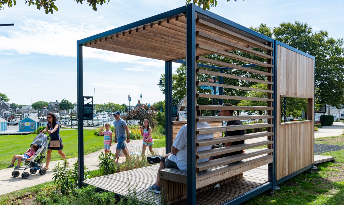
Wayfinding found along Resilient Woods Hole, a walking trail led by markers that promote conversation on the local effects of climate change and sea-level rise. Photo courtesy of Jane Doucette, Woods Hole Oceanographic Institution.
We might say that all wayfinding is a way of perceiving and discovering and making sense of the world, so it is highly useful in design and in considering a person’s point of view when experiencing a space. In the terms of urban theorist Kevin Lynch, “a mental map” or “environmental image”[2] is formed by users as they circulate through a city, building or landscape and this “image” sustains a coherent picture and relates the parts and the whole for making sense of the world.
It is interesting to note that most people are generally unaware or unconscious of their innate wayfinding capabilities, yet nearly everyone has a unique, organically-developed and often self-refined talent to navigate. When faced with new or familiar journeys, people are actually engaged in a complex process of receiving many environmental stimuli, processing them, and updating and renovating the original “mental map” to a more useful, meaningful version. Lynch notes that building this image is a two-way process between the observer and the environment. “The environment suggests distinctions and relations, the observer with great adaptability in light of his own purposes selects, organizes and endows with meaning what he sees.”[3]
Quality interpretive wayfinding design allows visitors to move confidently and freely through a space of all scales and types and recognize other highlights and features that have space to make a deeper impression. It also presents a unique opportunity in the world of interpretation not just in terms of movement and image, but of more subtle qualities like smell, kinesthetics, taste, touch, color, light and ultimately, a heightened imagination and desire to engage the world more actively. These qualities make interpretive wayfinding a naturally occurring design operation in museums and cultural sites and anywhere an institution wants to more closely connect with its users, and vice versa. Beyond making connections, institutions are finding ways to move from education to action, an ethos that was well-summarized by Tilden in this quote, ‘‘Through interpretation, understanding; through understanding, appreciation; through appreciation, protection[4].’’
Leading the Way
While museums and institutions are defined by their buildings, collections, programs, and missions, many have placed a newfound emphasis on connecting with their neighbors, and local surroundings by meeting visitors where they are and how they arrive. One successful way of connecting is to take a wider, more holistic approach to the visitor’s journey and learning experience through interpretive wayfinding, which is uniquely suited to:
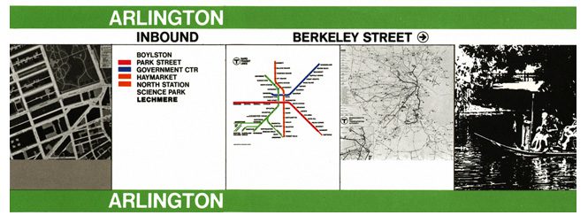
Create legibility and a common public experience: Nothing unites people like shared activities in daily life. Whether commuting, shopping, recreating, or learning, design can greatly clarify and enrich basic experiences by emphasizing a sense of place. The reorganization and re-branding of the MBTAbeginning in the 1960s was a breakthrough project for our office and for transit systems worldwide, combining an architectural renovation of stations, standardization of directional signs, addition of visual cues corresponding to above-ground monuments, and a public arts program provided a template for the multi-disciplinary, holistic approach to the modern transit system.
The MBTA Design Guidelines defined the local color-coded subway system, which is still used today.
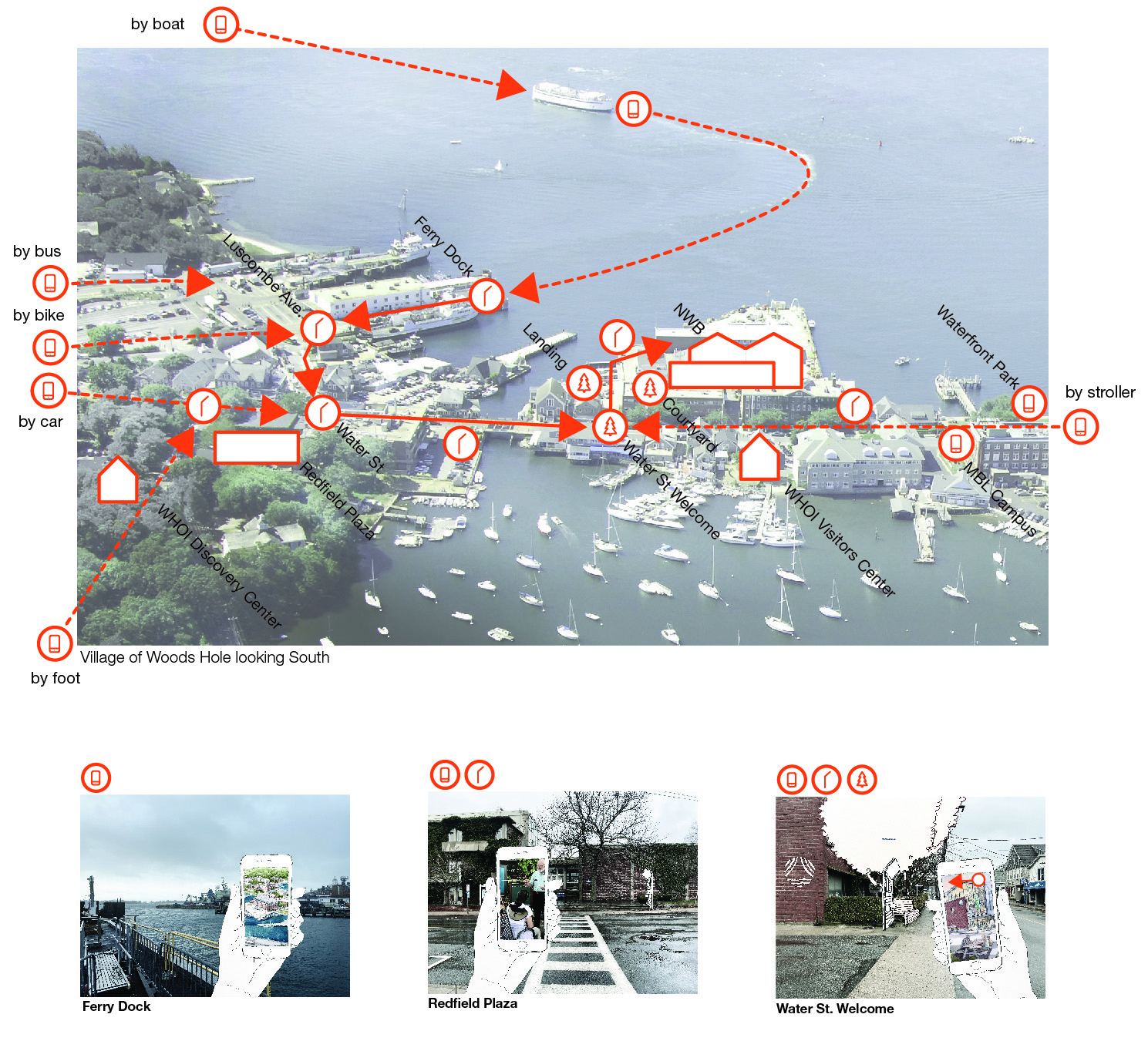
At Woods Hole Oceanographic Institution, designers crafted a wayfinding journey that spanned and connected the town.
Connecting people and experience:
By bringing visitors into contact with experts, whether fishermen, scientists, entrepreneurs, artists, or shop owners, the interpretative experience can be greatly enhanced by facilitating human-to-human contact around compelling subjects and vocations. The village of Woods Hole is a fascinating place with world-famous marine research institutions, intense ferry activity and a unique coastal culture, yet the millions of visitors scarcely appreciate this or confidently know where to walk, park or ride bikes. Woods Hole Oceanographic Institution recognized this challenge and has been working with us to craft a village-wide visitor journey that creates organized points of contact with the “real work in real time” by scientific organizations and business owners in a loop of discovery aided by signs, digital resources and a trail of real and fascinating marine science artifacts. We worked closely with collaborators sparks+sullivan on issues of brand identity and audience needs by using data-driven assessments and on-the-ground interviews of visitors to shape the design.
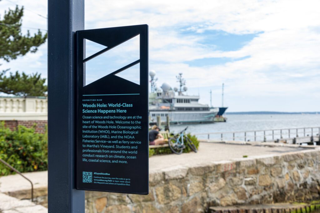
Reveal authentic places and landscapes: Because interpretive wayfinding opportunistically unfolds out of doors, the subject often embraces the natural world and can heighten the experience of cherished natural spaces. We have found that amazing phenomena are “hiding in plain sight.”. Through a sign program that shares subtle cues and frames evocative views, we developed a region-wide interpretive trail for Expedition Blue, which supports the Cape Cod Chamber of Commerce’s goal of developing the “blue economy,” that is, water based economic development that is keenly aware of the fragile ecology of the region. The project uses a series of kiosks, signs, shelters, brand identity, QR code links to digital assets and native plantings to raise awareness of ecological economic opportunities, especially for young Cape residents and new entrepreneurs. We collaborated again with sparks+sullivan and embraced a regenerative landscape design led by Bishop Land Design.
Expedition Blue interpretive wayfinding features interactive elements such as scannable QR codes.
Accessible pathways, gathering spaces and educational, interactive signage create the Gloucester HarborWalk, an outdoor museum. Photo courtesy of Kim Smith.
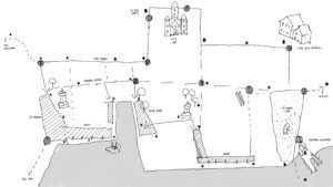
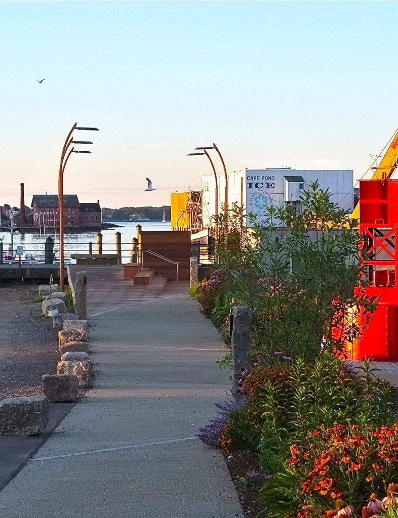
Curate an outdoor museum: By capitalizing on existing public spaces and pathways, interpretive wayfinding can provide an enriched layer of meaning and improved clarity and connection between existing assets. The existing inner harbor of Gloucester, MA, is home to an abundance of artistic, scientific, maritime, and natural history, yet residents and visitors had little sense of this Working closely with Carolyn Kirk, Mayor of Gloucester at the time, we developed the Gloucester HarborWalk which connected the nodes of public spaces, institutions, businesses, and wharves with new pathways to give residents and tourists new perspectives on a special place that often escapes notice. The project has become both an outdoor museum for visitors and an outdoor classroom for local schools with a simple kit of 42 “story posts” and maps, with additional curation by filmmakers, Walking Cinema, available via smartphone app; teaching us valuable lessons in hybrid digital-analog storytelling.
Widen access to space and content: Quality interpretive wayfinding can be a path to universal, inclusive, and human-centered design. It can create multi-sensory experiences that give users of diverse abilities and ages confidence to access and navigate their environment through a whole range of tools including tactile detection systems, 3D haptic maps, heightening opportunity for interaction with smells, sounds, weather, and digitally aided content. Again, the Gloucester HarborWalk put extensive weight on providing access to previously off-limits spaces with new ADA-compliant pathways and ramps to wharves and plazas, parallel activities for children alongside written interpretive text and tactile and textural experiences of rough-hewn local granite and three-dimensional pictograms for every unique story. Inevitable immersion in the smells, sounds and environmental conditions of the seaside environment only heightened the multi-sensory experience for a range of users.
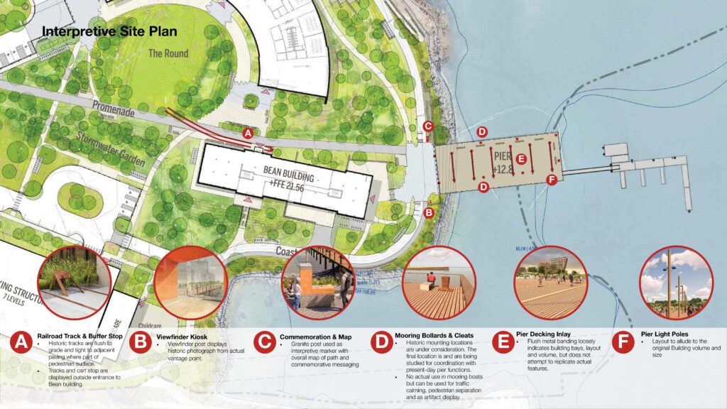
Envision future possibilities that are meaningfully connected to the past: The ability to represent historic scenes that no longer exist or project future scenarios which do not yet exist is another capacity of interpretive wayfinding. The Roux Institute at Northeastern University is in the process of developing a campus in Portland, ME, on the site of the Burnham & Morrill baked bean factory. The site is famous in the history of food innovation and is in the process of becoming a 21st century center of entrepreneurship campus. To link the past and present, the design weaves several tactical installations around the former industrial site and reveals the historic process including rail lines, maritime artifacts, tactile map of and a unique reimagining of a historic wharf building. In this case, we aligned historic photography of the building with a viewpoint along a new public coastal trail and reconstructed pier. Here we benefited from the deep research done by our client at IDEALS, Michael Cochrane, landscape architects Stimson and historic preservation architects Bruner Cott, in a robust public process to commemorate the historic fish house asset. In a similar manner, the adaptive-reuse Cambridge Foundry 101 used a consistent graphic approach to identify new community spaces, tell the important history of the local women’s labor movement, and invite future engagement in the public life of East Cambridge. Collaboration with the client, The Cambridge Redevelopment Authority and graphic designer Rena Sokolow was essential to synthesizing these themes with the sensitively repurposed architecture.
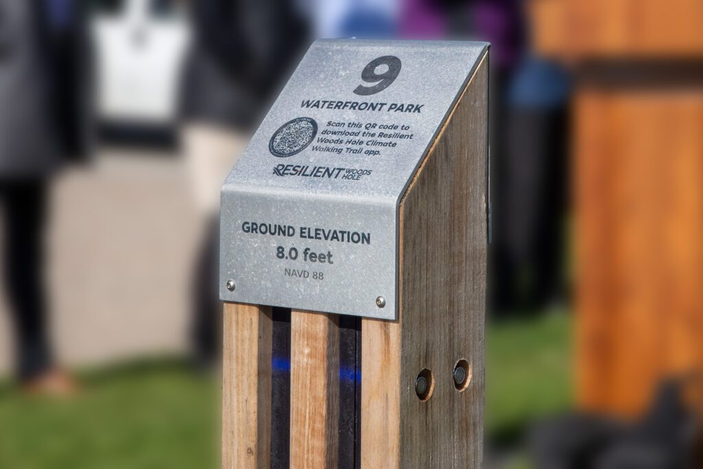
Provide effective, economical community communication: Interpretive wayfinding can use minimal means to support important community conversations with both speed and economy. In the sometimes-abstract dialog around climate change and sea-level rise, a point of common can often help advance conversations about why places are important. Resilient Woods Hole is a multi-stakeholder effort to increase the adaptability of a coastal village that is threatened by increased flooding and storms. To aid this process, we developed a simple, economical marker design for a walking trail that leads residents to 13 discrete, well-loved locations in the community and with QR code links, presents data about future risks and outlines a range of solutions for further discussion and action by all stakeholders.
design operation
Project success depends on collaboration, in particular clients, project managers and visionaries who have a keen understanding of the place, the purpose, and the potential of the project. As designers, we seek out local knowledge and expertise to access the deeper essence of a place. For this, it’s worth mentioning a specific collaborator, Leslie-Ann McGee of WHOI, Resilient Woods Hole and formerly of Cape Cod Chamber of Commerce. Leslie-Ann, and project champions like her, have shown particular vision around the potential of interpretive wayfinding to moving people through a place with a greater sense of purpose and capacity for action. From these partners and experiences, we’ve developed a working list of principles for interpretive wayfinding projects:
Consistent outdoor and indoor graphics at Foundry 101 tell the stories of local history while also aiding with wayfinding.
Practicing hospitality by anticipating the needs of different audiences
Establishing a personal connection between the users and seek to share something of value to the audience
Embrace change, especially in weather, seasons and events
Encourage discovery by leaving space for the visitor to “fill in the map”
Show, don’t tell
Use all the senses
Balance the reach of digital tools with the irreplaceable aura of objects, places and people
Collaborate extensively
Interpretive wayfinding is a serendipitous journey of discovery that neither gives away too little or forces too much on a visitor. It is an open experience that can spur discovery and adapt to a wide range of situations in the built environment for both arriving and thriving.
[1] Tilden, Freeman. Interpreting Our Heritage. University of North Carolina Press, 1977. p. 9
[2] Lynch, K. The Image of the City. MIT Press, 1960. p. 4
Timothy Mansfield, AIA, and Wonyeop Seok, AIA, discuss the new software and digital design tools used to create the breathtaking façade of the Roux Institute at Northeastern University in Portland, Maine.
Madeline Burns, AIA, LEED AP BD+C, CPHC highlights the importance of naturally biodiverse native landscapes in urban settings and what designers can do to create environments that are both sustainable and good design.